Two expeditions by Otto von Kotzebue (1815–1818 and 1823–1826)
The goals of the first expedition led by Kotzebue were: an attempt to find the northeastern passage from the Bering Sea to the Atlantic Ocean, to clarify the position of some islands in the tropical zone of the Pacific, as well as to conduct research work in hydrography, oceanography and meteorology. The tasks of the second expedition were to survey the Bering Strait, Alaska, and the tropical seas of Oceania. The expedition members visited the Easter Islands, Tuamotu, Marshall Islands, Hawaii, Tahiti, Samoa, and Guam (southern Mariana Islands), where they gathered valuable ethnographic information, discovered new islands and made important oceanographic and zoological observations.
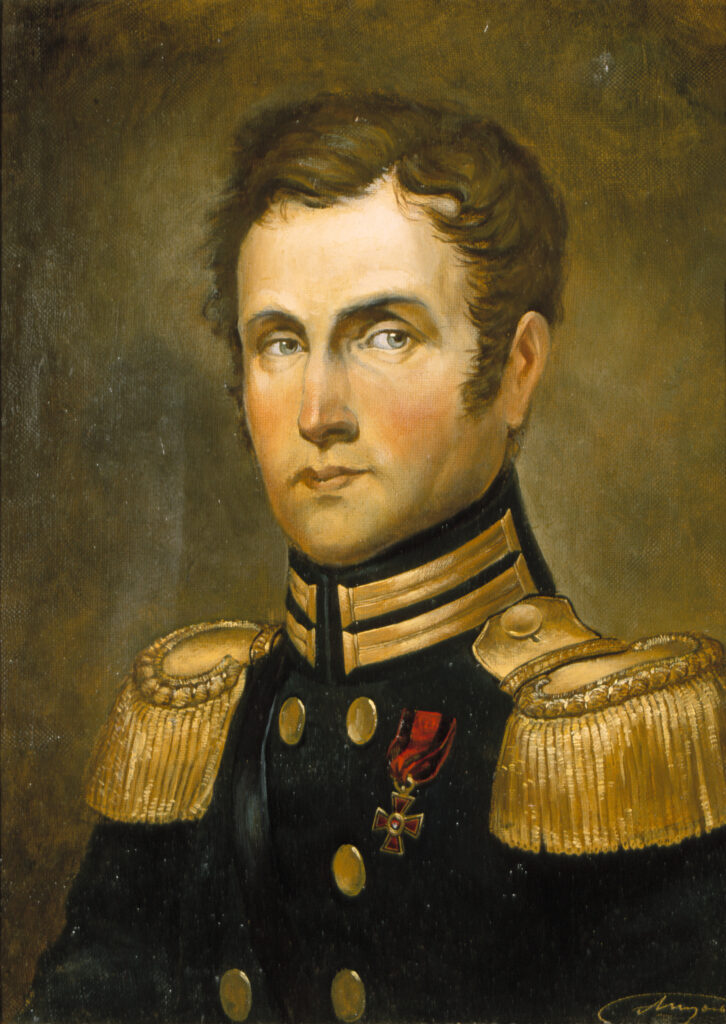
During his life Otto von Kotzebue made three voyages around the world, which in early XIX century Russia were an extraordinary event. He participated in Russia's first voyage around the world in 1803-1806 at the age of 15 as a seaman volunteer on the ship "Nadezhda", commanded by Adam Johann von Krusenstern, who was also his stepmother-uncle; the second time he circumnavigated in 1815-1818 at the age of 27 as captain of the brig "Rurik", specially designed for long voyages; and in 1823-1826, when Kotzebue was 35 years old, he made his third voyage around the world, in which he commanded the new, equipped with the latest science and technology sloop "Predpriyatie".
The first around-the-world expedition in 1815-1818 on the specially built "Rurik" was sponsored at his own expense by count N. P. Rumyantsev, the Chancellor of State, "the patron of science and art", the richest and most influential man in Russia, with the assistance of Krusenstern. Not surprisingly, Kotzebue named after Rumyantsev and Krusenstern a number of new geographical objects, which he discovered during his voyages over the Pacific Ocean. This expedition was unique in that it had no objectives other than scientific research, namely, to find a proposed northeastern passage from the Pacific to the Atlantic Ocean through the Arctic Ocean along the northern coast of the American continent, and to conduct hydrographic, oceanographic, climatic and ethnographic studies. In addition, the position of some islands in the South Pacific needed to be clarified in order to eliminate confusion in the maps which Krusenstern had worked to put in order. The scientific team included Dr. Johann Friedrich von Eschscholtz and naturalist Adelbert von Chamisso, after whom the bay and the island in the Chukchi Sea discovered by Kotzebue were named respectively.
Most of the geographical discoveries during the expedition on "Rurik" were made in the Pacific Ocean: in the northern part of the Tuamotu Archipelago in Polynesia Rumyantsev Island (nowadays Tikei) and Spiridov Atoll (nowadays Takapoto), Rurik Atoll (now Arutua), the position of Krusenstern Atoll (now Tikehau) was clarified, and other atolls of the archipelago, which were mapped by their predecessors in the XVI-XVIII centuries. In Micronesia, in the eastern Marshall Islands (Ratak Сhain, meaning "sunrise" in the local language), Kotzebue discovered Kutuzov Atoll (now Utirik) and Suvorov Atoll (now Toke), and he learned from the Ratak natives about the existence of the western chain (Ralik Chain, meaning "sunset" in the local language). With the scientists of his crew, he was the first to articulate the correct hypothesis for the origin of the atolls which was taken into account by Charles Darwin in developing his scientific theory on the formation of coral reefs and islands.
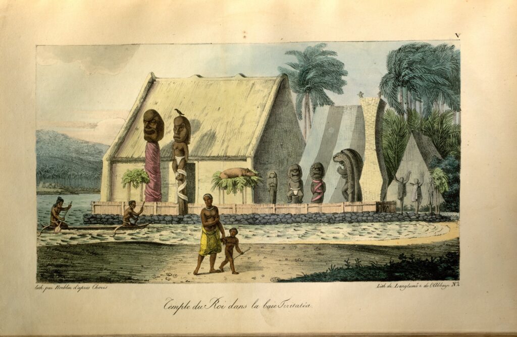
While sailing on "Rurik" in the South Pacific, Kotzebue and Chamisso made the first ever ethnographic notes about the inhabitants of the Marshall Islands and added significantly to the data about the people in Hawaii and the Mariana Islands. Familiar with the basics of Polynesian and Micronesian languages, the linguistically gifted naturalist Chamisso concluded that they were related to Malay and came up with the correct theory that Micronesians and Polynesians were of Asian origin. The items of everyday life of the inhabitants of the Pacific Islands collected during Kotzebue's expeditions are stored in the Peter the Great Museum of Anthropology and Ethnography (the Kunstkamera) in Saint-Petersburg.
The second around-the-world voyage in 1823-1826 was organized at public expense and was intended both for scientific research and for the delivery of necessary supplies to Kamchatka. For the expedition, 24-gun sloop "Predpriyatie" with a carrying capacity of 750 tons (the displacement of 8-gun "Rurik" was only 180 tons) was built. Through the efforts of Krusenstern, three students of the University of Dorpat (now University of Tartu, Estonia) - astronomer Ernst Wilhelm Preuss, mineralogist Ernst Reinhold Hofmann and physicist Heinrich Friedrich Emil Lenz, who later became the leading Russian scientist, was only 19 years old at the time of the voyage. It was his work aboard "Predpriyatie" that played an important role in the development of the new science of Oceanography.
During the second around-the-world expedition on the sloop "Predpriyatie" several dozen more islands were discovered in the Pacific Ocean. Kotzebue together with Lenz, for the first time in the history of exploration of oceans, made numerous measurements of the specific gravity, salinity, temperature, density and transparency of seawater in the temperate and hot zones. Lenz was the first to develop the bathometer (a device for taking water samples from the depths of the ocean).
During the two around-the-world voyages, 1815-1818 and 1823-1826, Kotzebue mapped 399 inhabited and uninhabited islands and atolls in the Pacific Ocean; to the South-East of the Bering Strait, the bay where the expedition team discovered fossil ice with a frozen mammoth tusk was named after him. Having studied the view and position of the Bering Strait, Kotzebue first suggested that Asia had once been connected with America. Deviations in the magnetic arrow were observed, and oceanographic, hydrographic and meteorological studies were carried out. The flora and fauna of the lands where "Rurik" and "Predpriyatie" came were also studied.
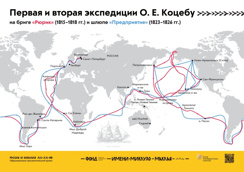
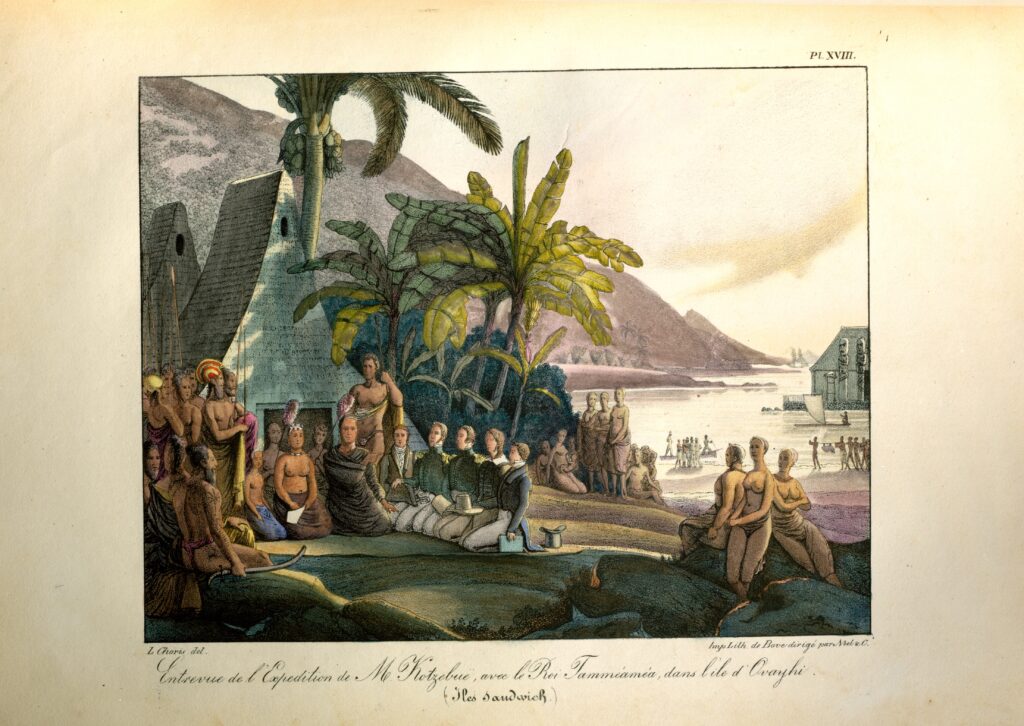
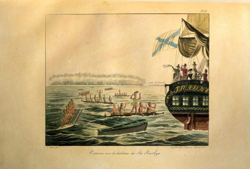
The route of the first around-the-world expedition of Kotzebue on "Rurik" in 1815-1818 led from Kronstadt through the Atlantic Ocean, calling at Tenerife to replenish supplies, then to the Brazilian island of St. Catherine, then "Rurik" rounded Cape Horn and after calling at the Chilean Bay Concepcion went on a long voyage across the Pacific Ocean to the coast of Kamchatka. Easter Island was the first island on "Rurik's" voyage to the South Pacific, followed by the discovery of an island in Polynesia which the navigator named Rumyantsev Island (now Tikei, an atoll in the Tuamotu Archipelago in French Polynesia), with definite traces of human presence; then the crew visited the inhabited island of Penrhyn (now Tongareva belonging to the state of Tonga); then they discovered inhabited atolls of Kutuzov (now Utirik) and Suvorov (now Toke) in the northern Marshall Islands in Micronesia; after that, Kotzebue headed "Rurik" to Kamchatka, where the expedition team arrived in June 1816. In October 1816, "Rurik" sailed to San Francisco, California, and from there to Honolulu, the capital of the Sandwich Islands (Hawaii) in Polynesia, where Kotzebue managed to meet the King of the Hawaiian Islands Kamehameha I. He then set a course for the newly discovered atolls of Kutuzov (now Utirik) and Suvorov (now Toke) in the Marshall Islands in Micronesia to see if there were any undiscovered lands, which was necessary to refine the atlas that Krusenstern had been working on. On 1 January 1817, an inhabited island, which Kotzebue called New Year Island (now Mejit), was found in the Ratak Chain in the Marshall Islands. Soon, some islands were discovered one after the other in a chain of 65 islands, called Rumyantsev Atoll (now Wotje). In February 1817, atolls in the Ratak chain, named of Chichagov and Arakcheyev Islands, were discovered. Then "Rurik" followed to Unalaska (an island in the Aleutian Islands near Alaska, the center of the Russian-American Company); from there, in October 1817, it arrived at the Sandwich Islands (Hawaii), then visited the Ratak Islands, after which it headed for the Mariana Islands, Rota and Guam Islands. After leaving the coast of Guam, "Rurik" set sail for home via Manila, Cape Town, St. Helena Island, where the English were holding imprisoned Napoleon, and, finally, via the captain's hometown of Revel (today's Tallinn) to Saint-Petersburg. Arriving in the capital, the ship moored on the Neva River right near the mansion of the State Chancellor, Count Nikolay Rumyantsev, at 44 English Embankment.
Kotzebue's second around-the-world voyage on the sloop "Predpriyatie" began on 28 July 1823. Leaving Kronstadt, the expedition team headed to Tenerife (Canary Islands), from there - to Rio de Janeiro (Brazil), in December, the sloop "Predpriyatie" rounded Cape Horn and in January 1824 anchored at Concepción Bay (Chile). After leaving in February 1824, the expedition team headed to the "heart" of Polynesia, Tahiti Island, and in early March, Kotzebue discovered a small inhabited island which he named after the sloop "Predpriyatie" (now Fakahina, Tuamotu archipelago in French Polynesia). During the expedition voyage Kotzebue examined the position of some Nizmennie Islands ("low islands", now Tuamotu Archipelago). The coordinates of Arakcheyev Atoll (now Fangatau) and Volkonsky Atoll (now Takume) discovered in 1819 by Fabian Gottlieb von Bellingshausen were checked and verified. Kotzebue rechecked the position of Rumyantsev Island (now Tikei) and Spiridov Atoll (now Takapoto), discovered by him in 1816, as well as Palliserovi Islands (Palliser Islands, now Arutua, Apataki, Toau and Kaukura atolls, discovered by J. Cook) and Greig Atoll (now Niau), discovered by Bellingshausen in 1819. After leaving Tahiti, Kotzebue headed for the Ratak chain and on the way, he decided to visit the Navigator Islands (now Samoa), as none of the navigators before him, neither Jacob Roggeveen, nor Louis Antoine de Bougainville, nor Jean-François de Galaup, comte de Lapérouse, had yet described the southern part of this Island. On the way, uninhabited reefs in the Marquesas Islands were discovered and named by Kotzebue after Bellingshausen (now Motu One). In early April 1824, "Predpriyatie" approached Maouna Island (now Tutuila, the largest island in the Samoan archipelago) and Fishing Island (now Nu‘utele) and Upolu Island, 45 miles from Tutuila, were mapped. After visiting the Ratak Islands, the sloop "Predpriyatie" headed to Kamchatka. From there, Kotzebue headed to California and, in December 1824, he sailed "Predpriyatie" to the Sandwich Islands (Hawaii), where it was anchored until February 1825, then again visited the northern latitudes and arrived in Honolulu in September.
After leaving Hawaii, the navigator sailed to the Utirik group of islands in the northernmost part of the Ratak Chain (within the Marshall Islands in Micronesia), where uninhabited islands were discovered, and then explored part of the Ralik Chain. Here, in October 1825, Bikini Atoll (Eschscholtz Atoll, where the Americans conducted nuclear tests from 1946 to 1958 and detonated the first hydrogen bomb in 1954) was mapped. "Predpriyatie" then set sail for the Ladrones (Mariana) Islands where, on the main island of the archipelago, Guam, the crew replenished food supplies.
After sailing off from Guam and calling at Manila (Philippines) in November 1825, the second around-the-world expedition on the sloop "Predpriyatie" proceeded to St. Helena and ended at Kronstadt on 10 July 1826.
Otto von Kotzebue was a man of lively temperament and sharp mind, an educator and humanist by nature, with a great sense of humur and inexhaustible optimism. He was concerned with enriching the diet of the inhabitants of Oceania with foods more familiar to Europeans, so that when they exchanged goods with the islanders they would get them: so, Kotzebue would bring animals (goats, pigs), offer locals to grow seeds of useful plants (watermelons, melons, peas, wheat, etc.), give iron tools to make farming easier - knives, axes, nails, etc., and gave them to people.
During the two voyages the expedition team witnessed a unique historical event - the settlement and development of new islands by people at the time of the migration of peoples in the Pacific. The information provided by Kotzebue about the population of the islands he visited, as well as his profound observations on the historical, political and social processes in the lands he saw, are invaluable for science. For example, the traveler's conviction that the King of the Hawaiian Islands Kamehameha I deserved a monument for his services to his country came true 70 years later: in 1883, the first monument to Kamehameha I was built in front of the royal palace in Honolulu. Kotzebue's subtle ethnographic analysis of the inhabitants of Oceania later helped to distinguish three cultural areas in the South Pacific: Micronesia, Melanesia and Polynesia.
Thus, Kotzebue's circumnavigations made an invaluable contribution to world science.
Литература
Зубов Н. Н. Отечественные мореплаватели – исследователи морей и океанов. М., 1954. https://e-libra.ru/read/532296-otechestvennye-moreplavateli-e-issledovateli-morey-i-okeanov.html
Кругосветные плавания О. Е. Коцебу // Библиотека путешествий. М., 2006. http://e-libra.su/read/403069-puteshestviya-vokrug-sveta.html#1667775139
Молчанов В. Ф. Государственный канцлер России, граф Н. П. Румянцев // Вестник РУДН. Сер. «Международные отношения». 2001. № 1. С. 176. https://cyberleninka.ru/article/n/gosudarstvennyy-kantsler-rossii-graf-n-p-rumyantsev/viewer
Отто Евстафьевич Коцебу. Путешествия вокруг света // Электронная библиотека. https://bookz.ru/authors/otto-kocebu/pute6est_383/1-pute6est_383.html
Here is a list of toponyms mapped during these expeditions:
Maloelap Atoll (Arakcheyev Atoll)
Motu One (Bellingshausen Island (Atoll))
Christmas Harbor
Likiep Atoll (Heiden Atoll)
Friendly Reception Islands
Jemo Island (Prince Saltykov Island)
Goat Island
Rose Island (Kordyukov Atoll)
Aratika (Kotzebue Atoll)
Ailuk Atoll (Krusenstern Atoll)
Tikehau (Krusenstern Atoll)
Utirik Atoll (Kutuzov Atoll)
Lagediak small Pass
Mejit Island (New Year Island)
Fakahina (Predpriyatie Atoll)
Bird Island
Rongelap Atoll (Rimsky-Korsakov Atoll)
Wotje Atoll (Rumyantsev Atoll)
Tikei (Rumyantsev Island)
Nu‘utele (Fishing Island)
Arutua (Rurik Atoll)
Rurik Strait
Puka-Puka (Somnitelny Island)
Takapoto (Spiridov Atoll)
Toke Atoll (Suvorov Atoll)
Aur Atoll (Traversay Atoll)
Erikub Atoll (Chichagov Atoll)
Shishmarev Strait
Bikini Atoll (Eschscholtz Atoll)